

| |
")
")
")
| Name | SLR_shimosato_station_data |
| Metadata Identifier | SLR_jhd_LRD20230727084734-en |
| Name | Geodesy and Geophysics office |
|---|---|
| Organization | Hydrographic and Oceanographic Department, Japan Coast Guard (JHOD) |
| Name | Geodesy and Geophysics office |
|---|---|
| Organization | Hydrographic and Oceanographic Department, Japan Coast Guard (JHOD) |
| Name | Geodesy and Geophysics office |
|---|---|
| Organization | Hydrographic and Oceanographic Department, Japan Coast Guard (JHOD) |
publication : 2014-07-01
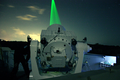
This is a SLR(Satellite Laser Ranging) data observed at Shimosato Hydrographic Observatory (SHO) and released in ILRS homepage.
oceans
| Begin Date | 1982-03-31 |
| End Date | Under Continuation |
| North bound latitude | 33.5777 |
| West bound longitude | 135.9370 |
| Eastbound longitude | 135.9370 |
| South bound latitude | 33.5777 |
| Keyword Type | Keyword | Keyword thesaurus Name |
|---|---|---|
| theme | GEODESY AND GRAVITY > Satellite geodesy: results, TECTONOPHYSICS > Plate motions: present and recent, GEODESY AND GRAVITY > Satellite geodesy: technical issues | AGU |
| theme | Earth Observation Satellites > LAGEOS (Laser Geodetic Satellite) > LAGEOS-1, Earth Observation Satellites > LAGEOS (Laser Geodetic Satellite) > LAGEOS-2, Earth Observation Satellites > AJISAI | GCMD_platform |
| theme | Solid Earth > Geodetics/Gravity > Crustal Motion | GCMD_science |
Homepage of Shimosato site : http://www1.kaiho.mlit.go.jp/KOHO/simosato/English/