

| |
")
")
")
| Name | Wave climate projection dataset 2022 |
| DOI | doi:10.20783/DIAS.642 |
| Metadata Identifier | KU_wave_climate_projection_202220230727103510-DIAS20221121113753-en |
| Name | Tomoya Shimura |
|---|---|
| Organization | Disaster Prevention Research Institute, Kyoto University |
| dias@oceanwave.jp |
| Name | DIAS Office |
|---|---|
| Organization | Japan Agency for Marine-Earth Science and Technology |
| Address | 3173-25, Showa-Cho, Kanazawa-ku, Yokohama-shi, Kanagawa, 236-0001, Japan |
| dias-office@diasjp.net |
| Name | Tomoya Shimura |
|---|---|
| Organization | Integrated Climate Model Advanced Research Program (TOUGOU Program) |
| Name | Tomoya Shimura |
|---|---|
| Organization | Integrated Climate Model Advanced Research Program (TOUGOU Program) |
publication : 2022-02-01
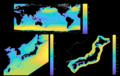
1) Ocean wave climate projection dataset created using the ocean wave model and the atmospheric global climate model (AGCM). The dataset consists of present climate data (3 ensemble members, 25 years each) and future climate data (4 members under RCP 8.5 scenario, 1 member under RCP 2.6 scenario, 25 years each). The domains are global (Spatial resolution: 0.5625 degree), western North Pacific (1/6 degree), and Japan area (1/15 degree). The AGCM data is based on "Climate projection data with 20km-mesh AGCM by SOUSEI program" (http://search.diasjp.net/en/dataset/GCM20_SOUSEI).
2) This dataset can be useful for coastal disaster risk assessment under climate change, coastal structure design, climate change impact assessment of coastal ecosystem, etc.
oceans
climatologyMeteorologyAtmosphere
| Begin Date | 1979-01-01 |
| End Date | 2099-12-31 |
| North bound latitude | 81 |
| West bound longitude | -180 |
| Eastbound longitude | 180 |
| South bound latitude | -81 |
| Dimension Name | Dimension Size (slice number of the dimension) | Resolution Unit |
|---|---|---|
| time | 1 (hour) | |
| row | 0.5625, 1/6, 1/15 (deg) | |
| column | 0.5625, 1/6, 1/15 (deg) |
| Keyword Type | Keyword | Keyword thesaurus Name |
|---|---|---|
| theme | Oceans > Ocean Waves > Sea State, Climate Indicators > Atmospheric/Ocean Indicators > Extreme Weather | GCMD_science |
| theme | GLOBAL CHANGE > Impacts of global change | AGU |
| Keyword Type | Keyword | Keyword thesaurus Name |
|---|---|---|
| theme | DIAS > Data Integration and Analysis System | No_Dictionary |
file download : https://data.diasjp.net/dl/storages/filelist/dataset:642
The file naming is as follows. KUwave_{experiment}_{YYYY}{MM}.nc ・{experiment} is the experiment name from SPA_m01, SPA_m02, SPA_m03, SFA_rcp85, SFA_rcp85_c1, SFA_rcp85_c2, SFA_rcp85_c2, SFA_rcp26. ・{YYYY} is year and {MM} is month.
Data Polilcy:
1. Individual users should not redistribute the data to any third party.
2. The source of the database should be acknowledged in scientific and technical papers, publications, press releases and other communications in case of using the data.
3. This dataset can be used for non-commercial purposes. For commercial use of this dataset, the prior explicit permission of the data provider must be obtained.
Disclaimer:
The intellectual property rights of the dataset belong exclusively to Disaster Prevention Research Institute, Kyoto university. Disaster Prevention Research Institute, Kyoto university is not responsible for any damage that may result from the use of this dataset.
If data provider does not have data policy, DIAS Terms of Service (https://diasjp.net/en/terms/) and DIAS Privacy Policy (https://diasjp.net/en/privacy/) apply.
If there is a conflict between DIAS Terms of Service and data provider's policy, the data provider's policy shall prevail.
The wave climate data is provided by Shimura and Mori (2019).
Shimura. T. and N. Mori (2019) FUTURE PROJECTION OF SPECTRAL WAVE CLIMATE AROUND JAPAN, Journal of Japan Society of Civil Engineers, Ser. B2 (Coastal Engineering), 75(2), p. I_1177-I_1182. https://www.jstage.jst.go.jp/article/kaigan/75/2/75_I_1177/_article/-char/en
If you plan to use this dataset for a conference presentation, paper, journal article, or report etc., please include acknowledgments referred to following examples. If the data provider describes examples of acknowledgments, include them as well.
" In this study, [Name of Dataset] provided by [Name of Data Provider] was utilized. This dataset was also collected and provided under the Data Integration and Analysis System (DIAS), which was developed and operated by a project supported by the Ministry of Education, Culture, Sports, Science and Technology. "
Shimura. T. and N. Mori (2019) FUTURE PROJECTION OF SPECTRAL WAVE CLIMATE AROUND JAPAN, Journal of Japan Society of Civil Engineers, Ser. B2 (Coastal Engineering), 75(2), p. I_1177-I_1182. https://www.jstage.jst.go.jp/article/kaigan/75/2/75_I_1177/_article/-char/en